CoCoNet (Co-creative Cohabitation Network)

Background
Cities face numerous global challenges, including demographic and economic change, mobility transitions, health issues due to pollution, as well as urban heat islands caused by climate change, and biodiversity loss due to fragmented natural habitats.
Decades of car-centric urban planning have contributed to the dominance of motorized traffic and associated spaces in public areas. As a result, open spaces such as green spaces and natural land have largely been fragmented or entirely replaced by sealed surfaces and built structures. By disrupting natural ecosystems in this way, ecological functions, also referred to as ecosystem services, are lost, and issues like urban heat islands, noise pollution, and inaccessibility of natural spaces within walking distance of homes and workplaces further intensify.
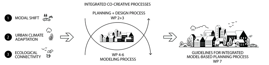
Addressing these interconnected issues in a data-driven manner instead requires a novel planning process that provides insights into how various measures and planning scenarios affect different domains, such as local climate, traffic flow, connectivity of natural habitats, and the soundscape, while also quantifying synergies and trade-offs between them. Thus, a planning process encompassing multiple key aspects of urban planning and explicitly recognizing the value of natural ecosystem services has to be developed.
Project goals
The mission of the CoCoNet project is thus to highlight synergies between transportation shifts, climate adaptation, and biodiversity, and in this way enable the co-creation of a sustainable and inclusive transformation of urban streetscapes at the neighborhood level.
The project focuses on the combination of mobility measures and nature-based solutions (NbS), aiming to position the coexistence of humans and other organisms as a central element of the urban planning process. By integrating two co-creative processes, CoCoNet seeks to bring together diverse stakeholders from different disciplines. This includes (1) the modeling of mobility, noise, climate, and ecological connectivity to identify spatial potentials and interactions, and (2) the planning and design of these aspects. The project encompasses further development of existing modeling and visualization tools, including a 3D web platform and audiovisual simulation of streetscapes.
Focus Areas
- Shifting urban car traffic toward more sustainable modes of transport, shorter travel distances, and more diverse, less traffic-dominated soundscapes (Topic Lead: yvp, ETH).
- Urban climate adaptation through urban greening, increased plant biomass, and sustainable urban retention, drainage, infiltration, and evaporation systems (nature-based solutions, NbS) (Topic Lead: TUW, ETH).
- Ecological connectivity that enables the coexistence of humans and animals in the city (Topic Lead: TUM, TUW)
Our Contribution- Ecological connectivity
In urban environments, the availability of resources has the greatest influence on the presence of animals (Beninde et al., 2015). However, due to the heterogeneous and barrier-rich nature of urban landscapes, the accessibility of resources is also crucial for an animal’s ability to establish itself in a city. The accessibility of resources is best described within the framework of ecological landscape connectivity.
Most existing modeling approaches focus on large-scale connectivity in landscapes outside of urban areas. The importance of small-scale structures in facilitating or hindering the daily movements necessary for individuals of a species to meet their basic needs is largely overlooked in most connectivity models.
In recent years, project partners (TUM, TUW) have developed a connectivity model that evaluates urban connectivity for animal species based on small-scale connectivity (Merkens et al., 2023). The model is based on a graph-theoretical approach (Graphab software), which represents ecological connectivity through nodes (resource patches) and network lines (connections between resource patches) (Merkens et al., 2023).
For the practical implementation of the CoCoNet concept, case studies will be conducted in selected neighborhoods of the cities of Vienna, Zurich, Munich, and Erfurt. To enable the co-creative process, we will collaborate with city administrations, local initiatives from the four targeted cities Vienna, Zurich, Munich, and Erfurt, and students in the field of urban planning.
Project Partners
TU Wien, Department of Landscape Architecture and Planning (Lead)
ETH Zürich, Department of Civil, Environmental and Geomatic Engineering
TU München, Lehrstuhl für Terrestrische Ökologie
Yverkehrsplanung GmbH, Wien/Weimar

Responsible People at TOEK
Prof. Dr. Wolfgang W. Weisser, E-Mail: wolfgang.weisser@tum.de
Ph.D.-student: Meret Pundsack, E-mail: meret.pundsack@tum.de
Related Literature
Abdelfattah, L., Deponte, D., & Fossa, G. (2022). The 15-minute city: interpreting the model to bring out urban resiliencies. Transportation research procedia, 60, 330-337.
Agusti, Carles et al. (2014). Co-Creating Cities. Defining co-´creation as a means of citizen engagement. 10.13140/RG.2.1.3684.5849.
Apfelbeck, B., Snep, R.P., Hauck, T.E., Ferguson, J., Holy, M., Jakoby, C., MacIvor, J.S., Schär, L., Taylor, M., Weisser, W.W. (2020): Designing wildlife-inclusive cities that support human-animal co-existence. Landscape Urban Planning. 2020, 200.
Beninde, J., et al. “Biodiversity in Cities Needs Space: a Meta-Analysis of Factors Determining Intra-Urban Biodiversity Variation.” Ecology Letters, vol. 18, no. 6, 2015, pp. 581–92.
Braaker, S., et al. “Assessing Habitat Connectivity for Ground-Dwelling Animals in an Urban Environment.” Ecological Applications, vol. 24, no. 7, 2014, pp. 1583–95.
Can, A., L’Hostis, A., Aumond, P., Botteldooren, D., Coelho, M.D., Guarnaccia, C., Kang, J. (2020). The future of urban sound environments: Impacting mobility trends and insights for noise assessment and mitigation. Applied Acoustics 170, 107518.
Logan, T. M., Hobbs, M. H., Conrow, L. C., Reid, N. L., Young, R. A., & Anderson, M. J. (2022). The x-minute city: Measuring the 10, 15, 20-minute city and an evaluation of its use for sustainable urban design. Cities, 131, 103924.
Merkens, L., Mimet, A., Bae, S., Fairbairn, A., Mühlbauer, M., Lauppe, E., Mesarek, F., Stauffer-Bescher, D., Hauck, T.E., Weisser, W.W., 2023. Connectivity at home: A data-driven connectivity modeling framework for home range movements in heterogeneous landscapes (preprint). Ecology. doi.org/10.1101/2023.12.22.571399
Newell, R., McCarthy, N., Picketts, I., Davis, F., Hovem, G., Navarrete, S. (2021). Communicating complexity: interactive model explorers and immersive visualizations as tools for local planning and community engagement. Facets 6: 287–316.
Perillo, Alyne, et al. “Anthropogenic Noise Reduces Bird Species Richness and Diversity in Urban Parks.” Ibis (London, England), vol. 159, no. 3, 2017, pp. 638–46.
Rădulescu, M. A., Leendertse, W., & Arts, J. (2023). How Can Co-Creation Support Capacity Building for Adaptive Spatial Planning? Exploring Evidence from a Co-Creative Planning Process in The Netherlands. Planning Theory & Practice, 24(5), 639–662.
Ritz, C. (2019). Modellierung und Wirkung von Maßnahmen der städtischen Verkehrsplanung [DoctoralThesis, Stuttgart : Institut für Straßen- und Verkehrswesen, Universität Stuttgart]. doi.org/10.18419/opus-10780
Tchervenkov, C. (2022). Empirical and simulation studies on parking in Switzerland [Doctoral Thesis, ETH Zurich]. doi.org/10.3929/ethz-b-000593365
Urech, Philipp R. W., Maria Angela Dissegna, Christophe Girot, and Adrienne Grêt-Regamey (2020): Point Cloud Modeling as a Bridge between Landscape Design and Planning. Landscape and Urban Planning 203: 103903.
Weisser, W. W., Hensel, M., Barath, S., Culshaw, V., Grobman Y. J., Hauck, T. E., Joschinski, J., Ludwig, F., Mimet, A., Perini, K., Roccotiello, E., Schloter, M., Shwartz, A., Hensel, D. S., Vogler, V. (2023). Creating ecologically sound buildings by integrating ecology, architecture and computational design. People and Nature 5 (1).